North Sea Upstream and Carbon Wallmap
Summary
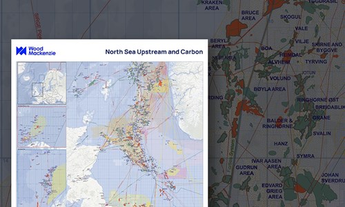
Wood Mackenzie has produced a detailed wallmap of the North Sea showing the latest information about Upstream oil and gas and carbon capture in the region.
The map shows active Upstream licences and fields and pipelines together with CCUS Licences, Projects, Storage fields and Saline Aquifers in Denmark, the Netherlands, Norway, and the UK.
The map allows clients to get a rapid appreciation of:
- The scale and nature of the oil and gas and carbon business in the North Sea area
- The location of the main oil and gas projects
- The location of the main carbon projects
- The level of infrastructure
Insert maps show additional information on:
- Norwegian Sea
- Norwegian Barents Sea
This map is an invaluable reference for anyone interested in the North West Europe energy sector.
Wallmaps bought online will be couriered to you.
Why buy a wallmap?
Our maps bring together trusted data and research from across the globe. And we have a team of analysts and researchers committed to ensuring the continued accuracy and consistency of data across the entire collection. With a Wood Mackenzie map, you can:
- Gain an instant visual appreciation of multiple assets and markets across global locations.
- Use them as reference documents in group discussions
- Get a single, reliable overview
What will you receive?
- Printed to make a big and lasting impression, each map is 84cm x 120cm or 33 inches x 46 3/4 inches on high quality paper
- Couriered to you when purchased online
- Delivered in a tough cardboard tube to ensure maps reach you in pristine condition
Other reports you may be interested in
Columbus
The small Columbus gas/condensate field lies in the Central North Sea, immediately north of the Lomond field. It was discovered in 2006 ...
$3,720Seagull
The Seagull high pressure/high temperature (HP/HT) field lies in the Central North Sea, 17 kilometres south of the ETAP (BP) Central ...
$3,720Bardolino
The Bardolino field lies in the Central North Sea, two kilometres east of the Howe field. It was developed as a single well subsea ...
$3,720