


Australasia Energy Wall Map
This report is currently unavailable
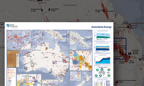
Summary
Wood Mackenzie has produced a detailed wallmap showing the energy industry in Australasia.
The map shows pipelines (by development status), gas and oil fields, active blocks, terminals, processing plants and power stations.
Insert maps show more detailed views of Carnarvon Basin, Browse Basin, Surat Basin, Cooper Basin, Gippsland Basin, New Zealand, Papua New Guinea, and a PetroView® subsurface profile.
In addition, charts provide the following information:
- East Coast gas supply and domestic demand
- Western Australian domestic gas supply and demand (2019 - 2027)
- Australia gas production by state (2009 - 2029)
- Australia's solar statistics – operational projects and projects under development
- A stratigraphic profile of the Beetaloo sub-basin from Wood Mackenzie's PetroView®
Wallmaps bought online will be couriered to you within 5 days.
Why buy a wallmap?
Our maps bring together trusted data and research from across the globe. And we have a team of analysts and researchers committed to ensuring the continued accuracy and consistency of data across the entire collection. With a Wood Mackenzie map, you can:
- Gain an instant visual appreciation of multiple assets and markets across global locations.
- Use them as reference documents in group discussions
- Get a single, reliable overview
What will you receive?
- Printed to make a big and lasting impression, each map is 84cm x 120cm or 33 inches x 46 3/4 inches on high quality paper
- Couriered to you when purchased online
- Delivered in a tough cardboard tube to ensure maps reach you in pristine condition
Other reports you may be interested in
Endeavor (Elura) zinc mine
A detailed analysis of the Endeavor (Elura) zinc mine.
$2,250Century Tailings zinc mine
A detailed analysis of the Century Tailings zinc mine.
$2,250West Whundo zinc mine project
A detailed analysis of the West Whundo zinc mine project.
$2,250


